Map - Abasha

Abasha
Abasha (აბაშა) is a town in western Georgia with a population of 4,941. It is situated between the rivers of Abasha and Noghela, at 23m above sea level and is located some 283 km to the west of Tbilisi. The settlement of Abasha acquired the status of a town in 1964 and currently functions as an administrative center of the Abasha Municipality within the Samegrelo-Zemo Svaneti region. The headquarters of the Georgian Orthodox Eparchy of Chkondidi is also located in Abasha.

The modern history of Abasha is primarily associated with a resonant Soviet-era economic experiment introduced by the Georgian Communist party chief Eduard Shevardnadze in the 1970s. In 1971, Shevardnadze grouped all regional agricultural institutions, including the kolkhoz, into a single management association. At the same time, those who worked on the land received material and financial preference. The move facilitated local initiative and coordination and led to a rapid increase in agricultural production in the previously very poor Abasha District. It had been the first private enterprise in the Soviet Union since Lenin. Early in the 1980s, the "Abasha experiment" was expanded, with varying degrees of success, to other regions of Georgia.

The word "Abasha" comes from Arabic. According to a legend, the Arabs wanted to cross the river, but it was swollen and they shouted at one another "Aba-sha" i.e. "retreat". According to the memoir by Juansher, a 23,000 Abyssinian infantryman of Ethiopian origin in the Marwan II's army in the 8th century drowned in one river, and the other river seized 35,000 horses. Due to that one river was named Abasha and the other one Tskhenistsqali.

 
Map - Abasha
Map
Google - Map - Abasha
Google
Google Earth - Map - Abasha
Google Earth
Nokia - Map - Abasha
Nokia
Openstreetmap - Map - Abasha
Openstreetmap
Map - Abasha - Esri.WorldImagery
Esri.WorldImagery
Map - Abasha - Esri.WorldStreetMap
Esri.WorldStreetMap
Map - Abasha - OpenStreetMap.Mapnik
OpenStreetMap.Mapnik
Map - Abasha - OpenStreetMap.HOT
OpenStreetMap.HOT
Map - Abasha - OpenTopoMap
OpenTopoMap
Map - Abasha - CartoDB.Positron
CartoDB.Positron
Map - Abasha - CartoDB.Voyager
CartoDB.Voyager
Map - Abasha - OpenMapSurfer.Roads
OpenMapSurfer.Roads
Map - Abasha - Esri.WorldTopoMap
Esri.WorldTopoMap
Map - Abasha - Stamen.TonerLite
Stamen.TonerLite
Country - Georgia_(country)
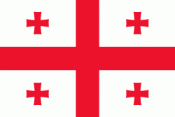
Flag of Georgia (country)
Georgia (საქართველო, ) is a transcontinental country at the intersection of Eastern Europe and Western Asia. It is part of the Caucasus region, bounded by the Black Sea to the west, Russia to the north and northeast, Turkey to the southwest, Armenia to the south, and by Azerbaijan to the southeast. The country covers an area of 69700 km2, and has a population of 3.7 million people. Tbilisi is its capital and largest city, home to roughly a third of the Georgian population.

During the classical era, several independent kingdoms became established in what is now Georgia, such as Colchis and Iberia. In the early 4th century, ethnic Georgians officially adopted Christianity, which contributed to the spiritual and political unification of the early Georgian states. In the Middle Ages, the unified Kingdom of Georgia emerged and reached its Golden Age during the reign of King David IV and Queen Tamar in the 12th and early 13th centuries. Thereafter, the kingdom declined and eventually disintegrated under the hegemony of various regional powers, including the Mongols, the Turks, and various dynasties of Persia. In 1783, one of the Georgian kingdoms entered into an alliance with the Russian Empire, which proceeded to annex the territory of modern Georgia in a piecemeal fashion throughout the 19th century.
Currency / Language  
ISO Currency Symbol Significant figures
GEL Georgian lari ₾ 2
Neighbourhood - Country  
  •  Armenia 
  •  Azerbaijan 
  •  Turkey 
  •  Russia